Close Menu
Terrain News
  • Environmental Science
  • Landforms & Habitats
  • Extreme Events
  • Watershed Restoration
  • Wildfire
What's Hot

Boulder County Firefighters Successfully Limit Wildland Blaze to Under One Acre

Expanding Stream Restoration Efforts Throughout Colorado

Impacts of Extreme Weather and Climate Events on Economy and Lives

Facebook X (Twitter) Instagram
Facebook X (Twitter) Instagram Pinterest
Terrain News
TerrainWorks
  • Environmental Science
  • Landforms & Habitats
  • Extreme Events
  • Watershed Restoration
  • Wildfire
Terrain News
You are at:Home»Watershed & Environmental Science»Drought Analysis and Trend Assessment in the Bilate River Watershed, Rift Valley, Ethiopia
Watershed & Environmental Science

Drought Analysis and Trend Assessment in the Bilate River Watershed, Rift Valley, Ethiopia

Terrain NewsBy Terrain NewsJanuary 18, 2025002 Mins Read
Share Facebook Twitter Pinterest LinkedIn Tumblr Email
Drought Analysis And Trend Assessment In The Bilate River Watershed,
Share
Facebook Twitter LinkedIn Pinterest Email

Drought is a complex natural hazard that leads to significant water scarcity, impacting agriculture, food security, and various economic sectors. It is characterized by a prolonged deficiency in precipitation, affecting ecosystems over extended periods. Recent trends indicate an increase in the intensity and frequency of droughts, partly due to global warming. Various drought indices, including the Standardized Precipitation Index (SPI), Standardized Precipitation Evapotranspiration Index (SPEI), and Palmer Drought Severity Index (scPDSI), are utilized to assess drought conditions. Each index has unique advantages and limitations, leading researchers to often recommend using multiple indices for comprehensive evaluation.

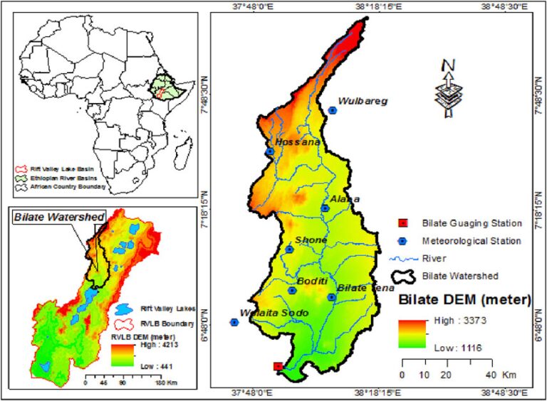
The study focuses on the Bilate River Watershed in Ethiopia, employing drought indices over four decades (1981-2019) to analyze drought characteristics using the Theory of Run and trend analysis. It revealed high correlations among indices at similar time scales, particularly effective for identifying historical drought events in notable years: 1984/85, 2000, 2002, and 2009. The analysis demonstrated that drought conditions have generally increased over time, with significant effects observed across different stations in the watershed. While Hossana and Wulbareg stations showed decreasing trends, the overall trajectory indicated worsening drought conditions, necessitating further research using enhanced data approaches, such as satellite imagery, for more accurate spatial assessments.

Source link

Analysis Assessment Bilate Drought Ethiopia Rift River Trend Valley Watershed
Share. Facebook Twitter Pinterest LinkedIn Tumblr Email
Previous ArticleCombating Desertification in China: Understanding Causes, Effects, and Solutions
Next Article River Restoration Funding Benefits Montana’s Wildlife and Farmers
leebenda
Terrain News
  • Website

Related Posts

Lehigh Valley Watershed Conference Attracts Nearly 200 Professionals and Volunteers to Bethlehem

October 15, 2025

Join the New Watershed Restoration Team in Kingsport

October 14, 2025

Klamath River: A Year of Renewal After Dam Removal

October 13, 2025
Top Posts

Harnessing Machine Learning to Enhance Extreme Weather Alerts

January 8, 202517 Views

Understanding Extreme Weather: The Link to the Climate Crisis

January 8, 202515 Views

Human Influence on Our Landscapes

January 8, 202514 Views
Stay In Touch
  • Facebook
  • YouTube
  • TikTok
  • WhatsApp
  • Twitter
  • Instagram
Most Popular

Harnessing Machine Learning to Enhance Extreme Weather Alerts

January 8, 202517 Views

Understanding Extreme Weather: The Link to the Climate Crisis

January 8, 202515 Views

Human Influence on Our Landscapes

January 8, 202514 Views
Don't Miss

Boulder County Firefighters Successfully Limit Wildland Blaze to Under One Acre

Expanding Stream Restoration Efforts Throughout Colorado

Impacts of Extreme Weather and Climate Events on Economy and Lives

Popular This Week

Enhancing Watershed Management through Hydrological Connectivity in a Changing Landscape

Elevated Wildfire Risk in North Texas on Sunday Due to Warm, Dry Conditions

Merrimack River Restoration Receives $228K Grant for Environmental Enhancement

© 2025 Terrain News. All Rights Reserved.
  • About Us
  • Privacy Policy
  • Terms and Conditions
  • Disclaimer

Type above and press Enter to search. Press Esc to cancel.